


How GIS real estate solutions can boost property sales
Updated September 8, 2025
 Summarize in ChatGPTSummarize in ChatGPT
When it comes to property decisions, it’s hard to find a more meaningful and influential factor than location.
Indeed, a building’s location can tell a property investor or buyer plenty about a profitable investment. As such, location criteria typically determines the price of a property.
Skilled real estate agents understand that the more location data and insights available, the easier it is to attract customers.
Technology solutions in the commercial real estate sector are rapidly evolving with GIS (Geographical Information Systems) solutions quickly becoming front-and-center.
With the help of 3D maps and unmatched data visualization, real estate brokers and property appraisers can finally take their sales to an entirely new level.
Content
Generally speaking, GIS, or geographical information systems, are essentially interactive 3D maps that visualize location data.
When it comes to presenting property data, these comprehensive tools have become the go-to solutions for brokers and appraisers.
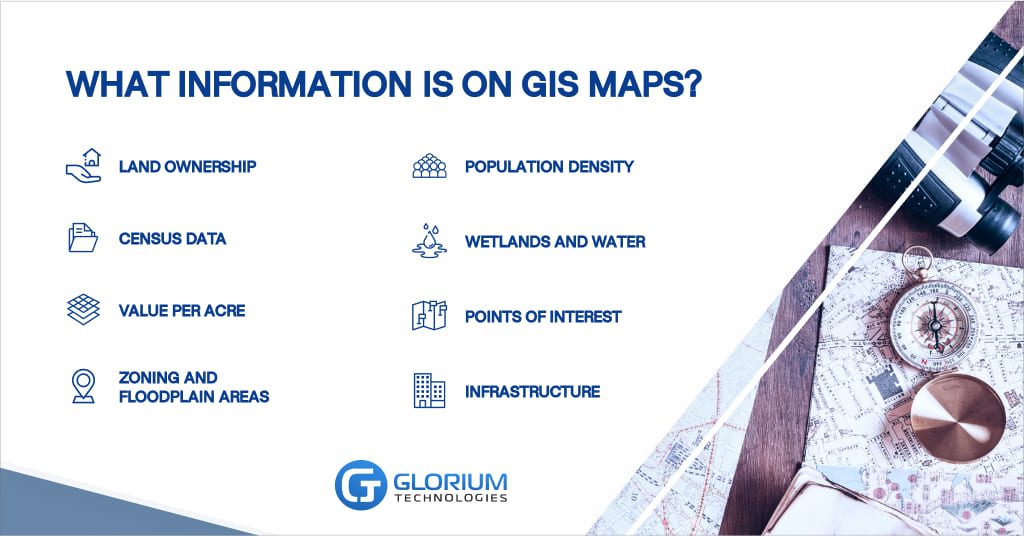
Typically, GIS maps contain various layers of information, including the following:
Until recently, real estate agents had to spend hours mulling over various types of property information in order to make profitable deals.
For an appraiser striving to provide an accurate valuation, the lack of available detailed information proved very frustrating.
Without a centralized information database to refer to, brokers and agents had to painstakingly compile all relevant information independently.
By compiling all of this information into an intuitive, refined, interactive mapping format, GIS software has made the appraiser’s job much easier.
Often, sales information regarding large tracts of land can be hard to come across; it can take days to compile all of the relevant information in order to create a write-up detailing comparable sales data for a credible analysis.
Agents also need visual comparisons to estimate the real estate value properly. With a GIS, data that is often found in multiple formats (including PDFs) across different websites is neatly compiled into an all-in-one interface where it can be accurately visualized.
Thanks to this, researching properties has become a swift and consistent process. Users can toggle data layers on and off and search for specific properties with ease.
Many GIS solutions even include links to relevant government websites and regulations in order to better direct users to the information they are looking for.
Thanks to location tools for real estate, industry professionals now have access to pre-collected data through visualized interactive maps to save time and resources.
For commercial real estate companies, having access to GIS software provides a competitive advantage. Companies can use these comprehensive maps to target customers more accurately; in addition, they also provide valuable insight into property ownership and location parameters.
The key advantage to using interactive 3D maps is that users can easily filter data by specific parameters instead of having to sift through layers of independent information.
Although plenty of property data can be located with a simple search on the Internet, still, it takes a ridiculous amount of time and in-depth knowledge to collect, sort, and compare it all correctly.
A reliable GIS takes care of all the research and provides you with access to information that would otherwise be impossible to access with a simple Google search.
The main difficulty with collecting location data manually is that it’s spread out all over the place. As there are numerous types of data and layers of information that need to be accounted for, things can get confusing extremely quickly.
As such, GIS interactive maps serve as a tool to centralize and accurately visualize volumes of property information.
Data visualization benefits not only brokers and real estate agents, but it’s also an appealing tool for presenting valuable information to customers, including property investors and buyers.
GIS visualization is especially helpful when customers wish to take a closer look at a property’s infrastructure and its proximity to nearby schools, office centers, retail clusters, etc.
The huge bonus of GIS maps for real estate professionals is that all information is updated in real-time. Previously, agents needed to manually search through information updates and compile layers of data to recognize patterns — GIS software does this in real-time.
Featuring multiple geographical data filters, real estate brokers can now sort and refine location information with customizable parameters.
Serving as a fundamental informational resource for real estate industry professionals, GIS maps are also reliable tools for researching the competition and analyzing the market.
Interactive maps present data updates in real-time, including the price of a property.
Additionally, information on GIS maps (for example, population density) provides agents with a quick glance at where their target audience lives which makes selling property a faster and more productive process.
Interactive 3D location maps facilitate the process of appraising property. Real estate agents can perform quick yet in-depth research into a specific area and compare prices in other locations with similar parameters.
Most importantly, by reducing the resources and overall effort spent collecting geographical information, GIS solutions enable brokers and real estate professionals to determine property prices more accurately. This in turn results in better business deals.
There is no shortage of GIS software solutions available on the market. From open relational databases that allow users to create customized maps, to ready-to-use solutions with default data. The following are some of the most widely used GIS solutions in the real estate industry:
Glorium is a software development company specializing in sophisticated tech solutions for the real estate sector.
With more than 10 years of industry expertise, Glorium assists startups, helping them get to market quickly and stay ahead of the competition with superior service and tailored solutions.
By nurturing your ideas from concept to launch, our dedicated team helps bring your ideas to life.
We can help you develop GIS mapping solutions to target your real estate customers. With in-depth experience in creating tech solutions for commercial real estate, you can rely on Glorium for sophisticated software development.
Learn more about our real estate software and application development solutions today.